


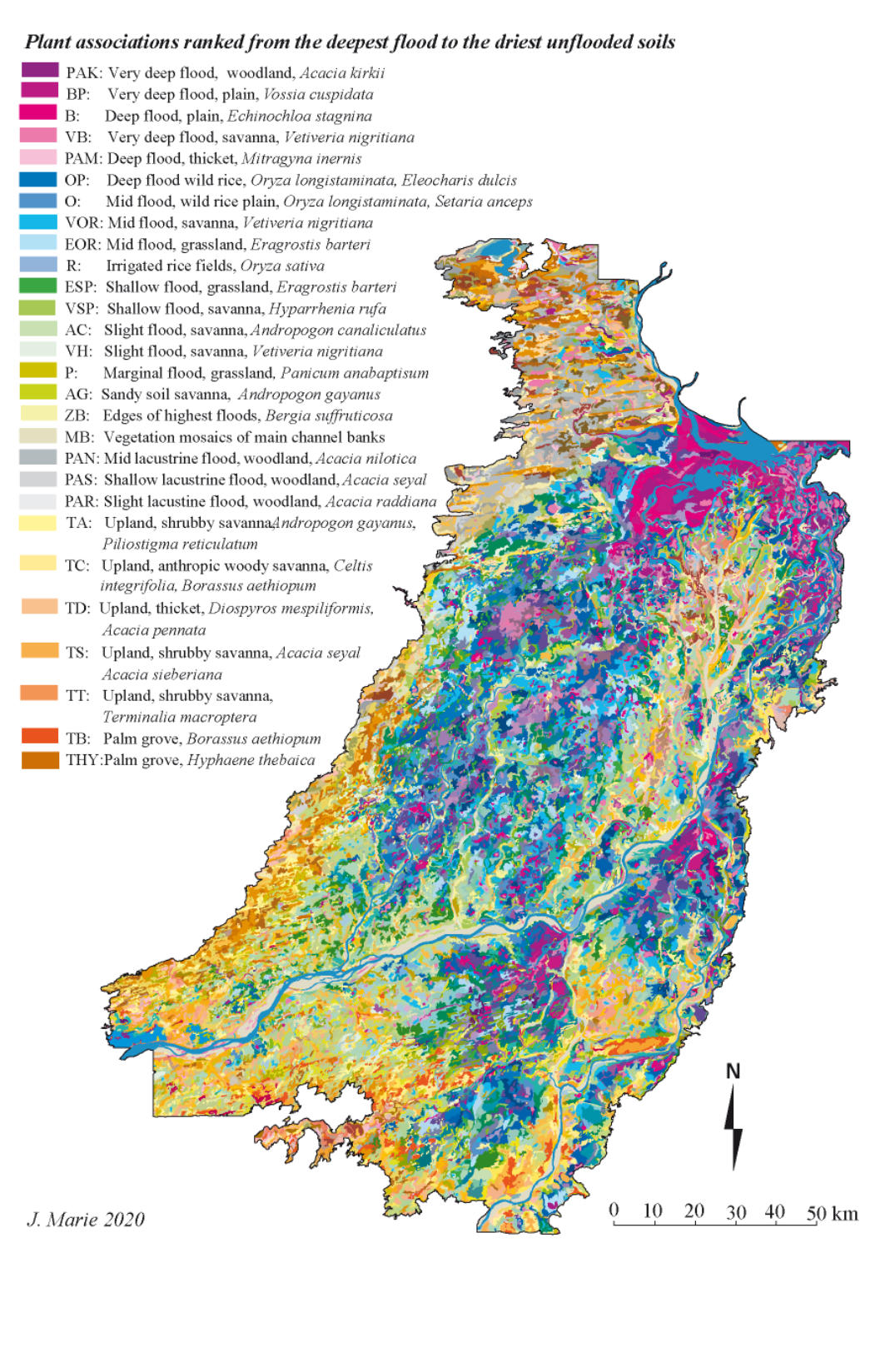
Vegetation
The
map
of
vegetation
types
comprises
120
different
types
(without
RIVER)
-
28
plant
associations
(with
MB)
and
92
mosaics
of plant associations. The principles governing the organization of the legend are as follows:
The
plant
associations
are
ranked
according
to
a
decreasing
flood
level
-increasing
dryness:
PAK,
BP,
B,
VB,
PAM,
OP,
O,
VOR,
EOR,
R,
ESP,
VSP,AC,
VH,
P,
AG,
ZB,
MB,
PAN,
PAS,
PAR,
TA,
TC,
TD,
TS,
TT,
TB,
THY.
The
ranking
by
decreasing
flood
levels
presents
one
exception,
with
the
complex
mosaic
found
in
the
river
major
bed,
MB
,
which
we
arbitrarily
placed
between
river
flooded
associations
and
those
flooded
by
run-off
and
late
river
flood
(PAN,
PAS,
PAR).
The
flood-dryness
gradient
applies,
with
local
run-off
and
late
flood
associations
PAN
being
more
heavily
flooded
than
PAS
and
PAR.
At
the
end
of
the
gradient,
dry
combinations
are
listed
in
alphabetical
order,
except
TB
and
THY
which,
being
on
sandy
substrate,
are
considered
to
be
the
driest
of all.
The
gradient
of
colors
used
in
the
legend
tries
to
translate
the
flood-dryness
gradient
as
closely
as
possible.
The
most
flooded
vegetation
types
are
given
colors
ranging
from
dark
purple
to
light
violet
(PAK,
BP,
B,
VB,
PAM),
then
a
range
of
blues
applies
to
the
combinations
with
wild
rice
(OP,
O,
VOR,
EOR,
R),
a
range
of
greens
to
the
less
deeply
flooded
combinations
(ESP,
VSP,
AC)
and
a
range
of
yellow
greens
to
the
weakly
flooded
associations
(P,
AG,
ZB).
The
color
allocated
to
MB
is
specific
(a
slightly
green
gray).
The
woody
savannas
flooded
by
local
run-off
and
late
river
flood
(PAN,
PAS,
PAR)
are
coded
with
three
specific
grays,
from
darkest
to
lightest.
The
upland
associations
are
given
warm
colors,
ranging
from
yellow
to
brown.
The
mosaics
being
combinations
of
associations,
the
120
vegetation
types
are
figured
on
a
square
matrix
of
28
by
28
associations
ranked
according
to
flood-dryness
as
described
above.
The
upper
left
box
of
the
matrix
(row
1,
column
1)
is
a
combination
of
the
first
element
of
the
gradient
-
PAK
-
by
itself.
The
diagonal
of
the
matrix
thus
represents
the
plant
associations.
The
mosaics
are
all
located
in
the
lower
half
of
the
matrix
and at the intersection of the two component associations, i.e. VOR/ZB is located at the intersection of column VOR and line ZB.
The
map
of
the
vegetation
types
shows
the
difference
between
the
low
lands
of
the
inland
Delta,
where
the
tones
range
from
the
purple
and
violet
of
the
deeply
flooded
associations
to
the
range
of
blues
and
greens.
Northeast,
the
Farimaké
is
distinguished
by
the
mixture
of
gray
tones
of
the
flooded
acacia
plains
streaked
by
the
warm
tones
-
orange-brown
–of
the
fossil
dune
alignments,
oriented
WSW
-
ENE.
The
western
margin
is
distinguished
by
its
warm
tones
from
the
low
lands,
with
the
greens
of
the
shallowly
flooded
high
plains
of
Diafarabe
on
the
left
bank
of
the
Diaka,
a
tributary
of
the
Niger
River,
and
the
blue
tones
of
the
Tenenkou
basin
on
the
right
bank.
Here
the
separation
between
the
inland
Delta
to
the
east
and
the
fossil
Delta
to
the
west
gradually
takes
place.
South
of
the
inland
Delta,
the
dry
margin
presents
a
complex
structure
dominated
by
the
main
dune
orientation
WSW-ENE
which
takes
the
southern
Delta
in
a
sling
and
finds
its
strongest
expression,
to
the
east,
along
the
shore
left
of
the
Bani,
whose
course
is
locally
guided
by the imposing mass of the erg of Femaye.
The
eastern
edge
of
the
Delta
a
contrario
appears
very
clear
with
almost
no
transition.
It
corresponds
to
a
very
clear
morphological
contact
between
the
alluvial
basin
and
sloping
sandy
erosion
surface
(10
‰
at
the
bottom
slope
N-E
and
S-E
of
the
Somadougou
hills).
The
north
of
the
Delta
corresponds
to
the
most
inundated
and
deepest
vegetation
types,
where
the
"bourgou"
associations
dominate,
mingling
with
the
open
waters
of
the
Debo
Walado,
which,
leaning
on
a
W-E
oriented
structural
lock
-
the
Homborian
according
to
J.
Gallais
(1966)-
closes
the
inland
Delta.
Further
north
begins
another
land,
related
and
yet
different
by
its
landscapes and ecology, that of the lake region.
If
the
inland
Delta
basin
appears
well
delimited
by
the
extension
of
the
flooded
associations,
it
is
far
from
homogeneous.
The
complexity
of
the
map
of
the
vegetation
types
suggests
basins
with
more
purple-violet
or
blue
tones,
less
flooded
plains
with
green
tones,
or,
as
in
the
Dialloubé
region
south
of
Débo
lake,
a
complex
arborescence
combining
the
pink-gray
tone
of
the
mosaics
of
the
banks
that
marks
water
arms
and
the
warmer
tones
unflooded
lands.
The
main
branch
of
the
Niger,
continuing
the
slow
west-east
migration
of
the
hydrographic
network,
is
now
completely
rejected
at
the
eastern
boundary
of
the
Delta.
Floodways
deriving
from
it
are
subtly
intertwined
with
a
fossil
arborescence
of
channels
that
are
not
flowing
anymore,
but
whose
presence
is
marked
in
the
landscapes
by
the
fossil
banks
with
specific
vegetation.
The
precise
layout
of
some
of
these
fossil
banks
towards
Dialloubé
corresponds to the course of the hydrographic network that J. Gallais (1966) dates from the 3
rd
Humid.(9300 to 6900 BP)
The
VEG4
cover
contains
14,535
map
units,
distributed
into
121
vegetation
types
over
a
total
area
of
2,229,950
hectares.
Of
the
121
vegetation
types,
one,
"RIVER",
represents
open
water
composed
of
5
units
(the
minor
beds
of
the
Niger,
Bani
and
Diaka
rivers,
and
the
lakes
-
53,497
ha).
Another
combination,
"TB/TC",
was
created
artificially:
it
occupies
731
units
figuring
the
built
surfaces
with
a
total
area
of
2
947
ha.
Finally,
there
are
13,799
vegetation
units,
which
are
distributed
between
119
vegetation
types,
associations
or
mosaics.
The
vast
majority
of
mosaics
(78
out
of
92)
represent
a
gradient
between
plant
associations
with
similar
or
close
flood
depth
and
are
thus
considered
"ecological".
In
a
smaller
number
of
cases
(14),
the
mosaics
span
over
contrasted
flood
regimes, and are thus "cartographic" mosaics.
The
average
area
of
a
vegetation
unit
is
158
ha,
with
extremes
ranking
from
0.3
to
12,270
hectares
(excluding
built
sites
and
open
water
surfaces).
The
mean
is
strongly
influenced
by
a
few
very
large
areas
and
poorly
reflects
the
size
distribution
of
the
Delta
vegetation
units:
half
of
the
units
extend
over
less
than
72.8
ha
and
only
10%
have
extended
over
more
than
369.3
ha.
Units
larger
than 1,000 ha only account for 1.8% of the total area. Only 0.2% reach 2,500 ha and 0,1% exceed 5,000 ha.
The
splitting
of
the
mosaics’
area
into
their
component
associations,
carried
out
by
granting
each
association
half
the
mosaic
area,
makes it possible to assess the area occupied by each of the 28 plant associations (including the bank mosaic, MB*).
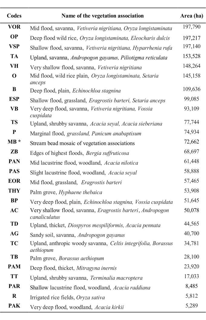
Table 1 : Codes and names of the twenty seven vegetation associations of the Inland delta of the Niger River
Vetiver
savannas
extend
over
about
30%
of
the
area
of
the
Inland
Delta
(including
Farimaké),
followed
by
unflooded
associations,
but
their
extension
depends
on
the
delineation
of
the
margins
of
the
Inland
Delta,
in
particular
the
western
margin.
Then
come
the
wild
rice
savannas
which
occupy
15%
of
the
area
of
the
Inland
Delta.
The
most
sought-after
rangeland
in
the
Inland
Delta,
the “
burgu
”, extends over only a little more than 7%, or about 160 000 ha.
If
the
same
area
assessments
are
made,
excluding
the
plant
associations
of
the
dry
lands
and
the
woody
plains
irregularly
flooded
by
run-off
and
late
river
flood,
the
distribution
of
the
plant
combinations
is
slightly
different
but
does
not
call
into
question
the
hierarchy
observed.
Ultimately,
the
floodplain
of
the
Delta,
the
kingdom
of
grass
and
water,
to
use
Jean
Gallais
'
s
expression,
is
not
the
undivided
kingdom
of
the
“
burgu
”.
The
Vetiver
savannas
of
lower
pastoral
value
come
first,
followed
by
the
wild
rice
stands. The “burgu” only comes at the fourth rank, with less than 10% of the area of flooded grasslands.


Download
Shape ArcGis Veg4
and data.rar