
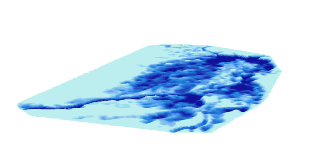
3D model of floodplains
To
try
and
solve
the
shortcomings
of
the
previous
model,
we
carried
out
a
matrix
model
by
converting
the
Veg7
map
layer
into
a
matrix
in
which
each
square
cell
of
100
x100
m
is
assigned
the
depth
that
is
characteristic
of
the
vegetation
association
in
the
cell.
It
is
then
possible,
for
any
depth
value,
to
draw
curves
of
"equal
flood
depth"
over
the
whole
Delta
and
thus
to
derive
maps
of
potentially
flooded
areas
for
each
flood
depth.
The
map
obtained
for
the
“0”
depth
value
corresponds
to
the
potentially
flooded
area
for
the
reference
flood
of
6.60
m
at
the
Mopti
gauge.
The
validity
of
this
approach
can
be
evaluated
by
comparing
the
result
with
the
spatial
extent
of
open
water
and
flooded
vegetation
in
Landsat
images.
This
model
does
not
intend
to
represent
the
propagation
of
the
flood
wave
across
the
Delta,
but
allows
us
to
estimate
the
potentially
flooded
area
in
relation
to
the
flood
measured
at
the
Mopti
gauge, year after year.
Four
Landsat
images
cover
the
Delta:
197_050
spreads
over
most
of
the
Delta,
197_051
over
the
southern
edge
(Pondori),
197_049 over the northern edge (Débo lake) and 198_050 over the southwestern edge (from Ké Macina to Diafarabé).
However,
it
should
be
noted
that
for
a
flood
height
between
6
and
6.60
m
at
the
Mopti
gauge,
the
flood
is
delayed
by
15
to
25
days
between
Ke
Macina
and
Mopti,
and
by
30
to
45
days
between
Mopti
and
Akka,
at
the
exit
of
the
Débo
lake.
Similarly
on
the
Bani
River,
the
delay
is
of
19
days
on
average
between
Douna
(upstream
of
the
Delta)
and
Sofara;
and
of
10
days
between
Sofara
and
Mopti
(for
a
6.30
m
flood
at
the
Mopti
gauge
).
So
the
maximum
extension
of
the
flood
might
be
reached
by
mid-October
in
the
south and not be reached until the end of November, or even in December, in the north of the Delta.
Moreover,
while
Landsat
images
have
been
available
since
1984
–
the
lowest
flood
of
the
century
–
the
collection
of
these
images
is
incomplete.
It
is
uncommon
to
have
a
series
of
good
quality
images
over
the
flood
season,
from
September
to
December,
for
each
flood
year.
Flooding
from
Mopti
to
Akka
results
from
the
combination
of
the
floods
(height
and
date)
at
Ké
Macina
on
the
Niger
and
at
Beneny
Kegni
(or
Sofara)
on
the
Bani.
As
we
will
see
further,
each
flood
is
unique
and
the
same
flood
height
in
Mopti
can
be
reached
in
different
ways,
sometimes
with
a
stronger
flood
on
the
Niger
and
a
lower
one
on
the
Bani,
or
the
opposite,
or
else
with
an
exceptional
lag
time
between
the
flood
of
the
two
rivers.
The
5.10
m
flood
of
1990
is
a
good
example
as
we
will
see
when
analyzing this flood.
Finally,
the
available
Landsat
images
were
often
taken
one
month
apart
from
one
another.
They
make
the
discrimination
of
water
and
green
vegetation
possible.
Analysis
is
based
on
R.O.I
(Region
of
interest)
tests
carried
out
in
the
different
environments
(clear
water,
turbid
water,
green
vegetation
with
high
reflectance,
vegetation
on
the
Sahelian
margins,
bare
soil)
that
can
be
identified on a colored composition such as Layer 753 (IFR SW2, near IFR, green) for Landsat 8 or 743 (IFR, Red, green) for ETM
The
classification
relies
on
maximum
likelihood
and
is
reported
within
the
limits
of
vegetation
units
in
VEG7.
Each
unit
is
visually
checked
against
a
classical
colored
composition
(543).
Whenever
possible,
this
check
is
performed
at
different
dates
for
the
west,
south,
center
and
north
of
the
Delta,
either
separately
or
complementarily,
with
the
same
unit
being
returned
to
at
different
dates.
Besides,
the
strong
development
of
woody
trees
on
the
toggere
–
unflooded
uplands
–
especially
in
the
south
of
the
Delta,
leads us to arbitrarily consider these areas as non-floodable and leave them out of VEG7
A
paper
submitted
in
February
2020
on
"The
drought
resilience
of
floodplain
vegetation
of
the
Inland
Niger
Delta
of
Mali"
by
Hiernaux
P.,
Turner
M.
D.,
Eggen
M.,
Marie
J.
and
Haywood
M.,
followed
a
field
trip
by
Pierre
Hiernaux
and
Matthew
Turner
made
during
the
2014
flood.
They
revisited
the
vegetation
sites
observed
between
1979
and
1986.
Their
analysis
of
vegetation
change
included
a
classification
of
numerical
data
derived
from
the
Landsat
images
based
on
the
NDVI
index
and
reflectances
in
the
mean
Infra-red
bands
and
was
performed
at
the
University
of
Wisconsin.
The
article
demonstrates
a
large
amount
of
resilience
of
the
Delta
vegetation.
It
can
remain
at
a
very
low
level
of
production
through
a
succession
of
very
dry
years,
then
resume
its
full
development
when
better
floods
return
without
much
change
in
the
composition
of
species
and
the
arrangement
of
vegetation
associations.
The
model
maps
the
potentially
flooded
areas
for
a
given
flood
height
at
the
Mopti
gauge,
compared
with
the
flooded
and
/
or
heavily
vegetated
areas
shown
on
the
Landsat
images
for
a
reference
year.
The
area
flooded
in
both
model
maps
and
Landsat
images
provides
a
confidence
ratio
for
the
model.
The
differences
(either
way)
between
model
output
and
image
can
also
be
precisely
localized.
However,
these
values
should
be
taken
with
caution
because
the
transposition
of
the
raster
image
within
the
limits
of
the
vector
cover
of
the
vegetation
map
(Veg7)
raises
a
problem:
the
vegetation
layer
contains
some
localization
errors
of
up
to
500
m
on
the
ground.
If
these
errors
have
little
impact
on
large
units
of
several
thousand
hectares,
they
have
a
large
one
on
small
areas
and
/
or
on
narrow
shaped
units.
Because
of
this
shortcoming,
it
proved
necessary
to
visually
check
nearly
14,000
vegetation
units
when
overlaying the "Landsat" information on Veg7, especially when part of the unit appeared flooded and / or heavily vegetated.
The
analysis
of
the
model
output
for
water
heights
of
6.60
m,
6.21
m,
5.97
m,
5.10
m
and
4.40
m
allows
us
to
assess
the
validity
of
the
model
"by
levels".
Without
fundamentally
questioning
the
model
approach,
it
suggests
its
output
should
be
qualified
and
consolidated
by
a
study
of
each
large
internal
basin
in
the
Delta.
It
is
to
be
noted,
for
example,
that
a
6
m
flood
at
Mopti
corresponds
to
a
slightly
weaker
flood
in
the
south
of
the
Delta
and
a
little
stronger
one
in
the
north.
This
trend
seems
to
be
even
more
marked
for
lower
floods.
Finally,
in
addition
to
the
logic
of
flood
patterns
in
relation
to
levels
and
to
basins,
local
factors
must
be
taken
into
account:
for
example,
a
deep-flood
vegetation
(VB)
unit
isolated
between
weakly-flooded
vegetation
units
could
be
less flooded than predicted by the model, as observed on the Landsat image, due to threshold effects.
However,
despite
all
these
reservations,
the
spatial
relationship
between
flood
levels
at
the
Mopti
gauge
and
flooded
areas
for
each
year
allows
for
plant
production
estimates,
regarding
spontaneous
vegetation
and
rice
crops
under
uncontrolled irrigation.
The practical realization of the model
In
the
Veg7
map
layer,
the
item
called
"PROFOND"
carries
the
depth
of
each
vegetation
association.
In
the
model,
the
flood
depths
are
coded
with
two
digits:
for
example
66
for
level
6
as
for
vegetation
association
(B),
and
65
as
for
mosaic
B
/
VOR.
The
flood-depth
calculation
is
as
follows:
each
vegetation
association
is
assigned
its
maximum
depth:
for
example
B
=
-2.80
m.
and
VOR
=
-1.50
m.
In
the
mosaics,
the
assigned
depth
is
the
arithmetic
mean
of
the
depths
of
their
component
vegetations.
For
example
B
/
VOR
is
therefore
assigned
a
depth
of
-
2.15
m.
The
off-Delta
environment
and
never-flooded
uplands
within
the
Delta
are
assigned
the
arbitrary
value
+1
m.
However,
for
mosaics
combining
flooded
vegetation
with
never
flooded
uplands,
the
latter
are
assigned
the
value
"0".
Thus
the
AG
/
TA
mosaic
is
assigned
a
depth
of
-0.30
resulting
from
the
depths
for
AG
=
-0.60
and
for
TA
= 0 (instead of +1 m when TA is by its own).
The
water
streams
(Niger,
Bani,
Diaka
and
the
great
Débo
lake….),
which
were
initially
mapped
as
a
unique
polygon
named
“RIVER”,
were
later
split
into
a
series
of
sections
to
which
we
allocated
flood
depths
based
on
data
from
the
Mathematical
Model
of the Niger River, a study carried out in the 1980s by ORSTOM – for the hydrology survey – and by IGN for the topography. These
surveys
enabled
SOGREAH
to
develop
the
"CARIMA"
model
simulating
the
flow
of
the
river
from
its
source
to
the
border
between
Niger and Benin, and Nigeria.
Moreover,
the
MB
mosaic
defined
as
"the
mosaic
of
the
river
banks",
is
a
complex
mosaic
whose
flood
depths
range
from
+1
to
-2.80
m
and
has
been
modified.
In
reality,
MB
covers
several
types
of
situations:
it
may
extend
on
the
river
bank
and
therefore
have
flood
gradients
from
"+1"
to
-2.80
m,
or
extend
mostly
on
channels
between
banks,
with
an
average
flood
depth
of
-2.80
m.
It
may
also
–
and
this
is
the
most
frequent
case
–
extend
over
a
complex
series
of
parallel
channels
and
levees
below
the
main
bank.
On
the
basis
of
an
analysis
of
the
rectified
aerial
photo
mosaic
built
for
the
Niger
River
Mathematical
Model
(IGN),
the
188
polygons
mapped
as
MB
vegetation
were
subdivided
in
two
categories:
MB1,
for
the
channels
with
a
depth
of
-
2.80
m
and
MB2,
for
the
mosaic of levees and channels with depths ranging from 0 to -2.8m, and therefore assigned a mean depth of “-1.40 m”.
(see and download Table 1: relationships between water depths and plant formations).
The
modified
layer
is
named
Veg7
and
was
converted
into
a
flood
depth
matrix
named
VEG7
by
overlaying
a
100*100m
grid,
where cells are assigned the maximum flood depth of the overlaid vegetation unit.
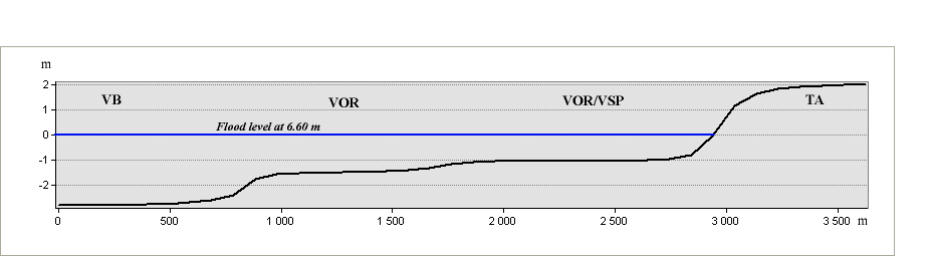
To
attenuate
the
gap
between
neighboring
vegetation
with
different
flood
depths,
we
applied
to
the
matrix
a
smoothing
Gauss
filter
of
500m
x
500m,
whose
results
approximate
the
topographic
profile
of
the
basins
as
shown
in
the
example
profile
produced
over 3500 m transect.
The
curves
of
equal
flood
depth
are
then
calculated
on
the
smoothed
matrix
VEG7K3
under
ArcInfo.
After
cleaning
the
"hanging
arcs",
each
curve
is
transferred
to
ArcGis
and
smoothed
using
the
Peak
algorithm
with
a
300
m
resolution.
The
corrected
curve
is
transformed
into
a
polygon
named
NIV_XXX.
For
example,
NIV_660
figures
the
potentially
floodable
areas
for
a
6.60
m
flood
at
the
Mopti
gauge.
After
the
removal
of
polygons
smaller
than
1
ha,
the
flood
contour
curve
is
established,
based
on
the
remaining polygons. The contour curve corresponding to flood NIV_660 is named L_660.
The issue of the Gaussian filter
When
two
adjoining
areas
have
very
different
flood
depths,
smoothing
out
the
difference
by
using
a
500x500
Gaussian
filter
results in a shifting of boundaries, so that the areas calculated as flooded by the model are marginally modified.
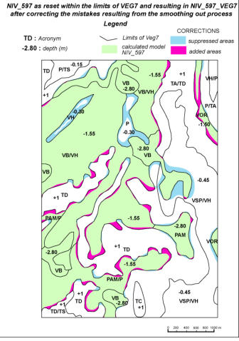
Fig 3 : The raw Model Fig 4 : The corrected model

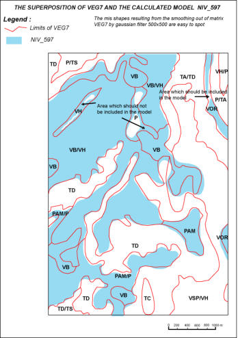
In
the
example
above,
taken
from
the
analysis
of
the
5.97m
flood
at
Mopti,
one
can
clearly
see
that
associations
P
and
VH,
with
a
depth
of
only
-0.30m,
are
partly
included
in
the
calculated
model,
whereas
VOR,
which
has
a
-
1.50m
depth,
undergoes
a
cut
that
is
not
justified by a variation in depth.
Those
differences,
whether
positive
(P_VH)
or
negative
(VOR),
only
marginally
modify
the
estimation
of
flooded
areas
(by
about
2%)
but
they
introduce
fragments
of
vegetation
associations
which
do
not
belong
to
the
model
into
it
(P,
VH,
VSP/VH….)
or
conversely
deprive
the
model
of
fragments
of
areas
that
belong
to
it
(VOR, VB/V...)
When
comparisons
are
made
with
the
flooded
areas
shown
by
Landsat
for
the
year
corresponding
to
the
flood,
the
risk
is
that
the
shape
files
showing
areas
that
are
common
to
the
model
and
the
Landsat
pictures,
as
well
as
in
those
displaying
the
additional
or
missing
areas,
might
include
such
“alien”
vegetation
associations.
Despite
the
limited
area
concerned,
the
analysis
would
nevertheless
be affected.
We
have
therefore
decided
to
use
a
spatial
operator
in
order
to
erase
such
“mistakes”
resulting
from
the
smoothing
out
process,
as
shown by that very same example after the correction has been made (figure 4).
For
each
example
of
flood
height,
we
shall
indicate
both
the
“raw”
area
calculated
by
the
model
and
the
“corrected”
area
used
for
comparisons.
I
n
the
following
examples
(pages
44
to
48),
we
have
“normalized”
the
names
given
to
the
“shape”
files,
taking
the
5.97m
flood and the year 2006 as references)
NIV_597
: is the « raw » model as calculated for the 5.97 m height at Mopti
NIV_597_VEG7
:
is
the
calculated
model,
as
re-positioned
within
the
limits
of
Veg7
and
corrected
as
to
the
effects
of
the
smoothing out process
VEG_2006
: shows the results of the analysis of the Landsat images for the year 2006 (corresponding to the 5.97 m flood)
COMMUN_597_2006
:
shows
the
flooded
areas
common
to
the
calculated
model
(NIV_597_VEG7)
and
the
Landsat
images
(Veg_2006). Flooded areas include water and vegetated areas with a high degree of reflectance
INON_MOINS_2006
:
is
a
shape
file
representing
the
areas
calculated
as
flooded
by
the
model,
but
not
appearing
as
such
on
the
Landsat images
INON_PLUS_2006
:
is
a
shape
file
representing
the
areas
appearing
as
flooded
on
the
Landsat
images
but
which
were
not
calculated as flooded by the model.
SYNTHESE_597_2006
:
represents
flooded
areas
common
to
the
model
and
the
images,
as
well
as
those
in
adddition
and
those
missing (Synthese_597_2006 = commun_597_2006 + inon_moins_2006 + inon_plus_2006).
We shall invite you to download two shape files :
NIV_597 et SYNTHESE_597_2006
The items in synthese_597_2006 will make it easy to extract the shape files: commun, inon_plus, inon_moins and Veg7_2006
Download
VEG7.gdb.rar contains the VEG7 shape file and the VEG7k3 matrix.
The water depth table is in excel format.
Veg7.rar